Innovation. Openness. Professionalism.
Geometric Design
Digital terrain modelling, visualisation and infrastructure coordination
[flexy_breadcrumb]
Mine Planning & Design
Airport Planinng & Design
Geometric Design
Optic Fibre Solutions
Geotechnical & Pavements
Financial Modelling
Structural Engineering
Electrical Engineering
Water & Wastewater Engineering
Independent Technical Review
EPCM & Owners Team
Geometric Design
Geometric design is a service which Nurizon offers across a number of its market sectors and involves the positioning of the physical elements of a site. It is integral with two-dimensional site layout planning. Highway (roads) engineering geometric design comprises route alignment, longitudinal (vertical) profiling, and horizontal and vertical cross-section profiling. Airport geometric design, as an example, uses the same 3D principles for linear infrastructure e.g. runways, taxiways and airside service routes, but may also include wider-area layout and site profiling requisites, e.g. aircraft aprons, engine run-up facilities and landside environment profiling.
Our geometric design engineers and technicians are intrinsically involved in the large majority of our engineering projects due to the very nature of geometric design. Personnel use the latest 3D modelling software to create digital terrain models (DTMs) for a site, which can then be interrogated for accurate bulk earthworks, pavement and layerworks quantities, to be used in project costings. Earthworks models assist in cut and fill earthwork balances for a site, helping to maximise the use of in-situ material, whilst reducing (as far as practicable) the requirement for commercially sourced materials. DTMs are also used to aid design engineers with visualising how a proposed development will integrate with its surrounds, as well as with other service designs where multidisciplinary projects are concerned, e.g. stormwater reticulation, structures and above-ground services lines.
Vehicle tracking software is often used for swept-path analyses to refine horizontal (and vertical) geometric layouts, e.g. sizing of aircraft aprons and taxiway fillets, or vehicle movement areas in a car park. Industrial engineers work together with our engineers on various projects to simulate and optimise geometric and facility layouts, especially where a time-critical component is concerned.
Our project portfolio showcases a range of geometric design projects across our business sectors.
Geometric Design Services
Layout planning, site profiling and integration
Integration of multidisciplinary service models
Mine site profiling and haul road geometry
Vehicle swept path analysis
Airport airside and landside environment modelling
Aerodrome obstacle limitation surface analysis
Road geometric design
Paint markings layouts
Project Showcase
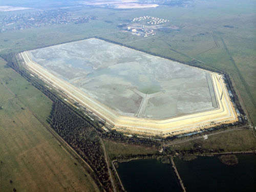
Syferfontein Megacity Development, Gauteng
July 2015 – ongoing
Project:
Roads and Stormwater Design: Preliminary Stage
The Gauteng Department of Human Settlements (GDHS) (Gauteng Provincial Government) released a ‘radical’ human settlements ‘mega projects’ strategy in April 2015 to cover housing development in the province over the 2014/15 – 2018/19 (5 year) period. The plan seeks to transform urban planning and coordinate housing development through the delivery of self-contained economies of no fewer than 15,000 units and up to 60,000 units (low to high income residential units), compared to previously sporadic, small and isolated developments. This is also hoped to ease housing backlog pressures.
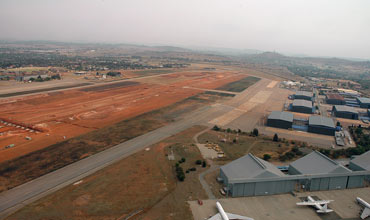
Waterkloof Air Force Base, Gauteng
2008 – 2013
Project:
Airport Upgrade: Detail Design Phases 1 and 2
Aurecon, together with Nurizon personnel, were appointed as part of a 3-member JV to undertake the design works associated with the upgrades for the Waterkloof Air Force Base (AFB) primary and secondary runways.
Upgrade works were required at the AFB due to its strategic and national importance in South Africa and to bring the aerodrome facilities in line with International Civil Aviation Organization (ICAO) standards, e.g. physical characteristic compliance and visual aids compliance. The base was also to serve as a strategic diversion airport for OR Tambo International Airport A380 (and other wide body aircraft) operations.
Nimba Iron Ore, Guinea and Liberia
May 2014 – Dec 2015
Project:
Preliminary Mine Haul Road Design and Geotechnical Investigation
Sable Mining Africa Ltd. obtained an iron ore mining concession in the Mount Nimba region of the Republic of Guinea, with Phase 1 of the project comprising the extraction of 3Mtpa DSO (Direct Shipping Ore) from the concession area.
Iron ore product was to be transported from the mine site to the Port of Buchanan, from where it was then to be exported.